Beginning approximately 15,000 years ago, ice dams on massive Lake Missoula in Montana began to break, sending torrents of deep water rushing through Idaho, Washington, and Oregon. The process continued for thousands of years with up to 40 major floods eventually forming what is now the Columbia River Gorge. The geology and climate of the gorge is as diversified as its scenery. In a 40-mile stretch west to east—from Multnomah Falls to The Dalles—the climate changes from that of a rain forest to a near desert. Rainfall in the western gorge can reach 70 inches per year. To the east, near The Dalles, it averages just 13 inches.
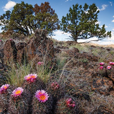
Dozens of magnificent waterfalls grace basalt cliff walls, cascading hundreds of feet to join the Columbia River. Each season brings a different look and feel to the region. Floods during the glacial age moved soil and rock, carving deep canyons and bluffs and leaving shallow soil in many areas where, in springtime, hundreds of varieties of wildflowers flourish. Summer sees the landscape turn to shades of beige and brown. By fall, the oaks and maples—interspersed with some evergreens—burst into vibrant color.
Barbara Robinson of Rowena, Oregon, has spent most of her adult life in the gorge area. She helped raise funding to purchase key tracts of land such as the Tom McCall Preserve at Rowena that today is managed by the Nature Conservancy, the State of Oregon, and the U.S. Department of Agriculture. The preserve is open for the public to enjoy. She serves as president of Klickitat Trail Conservancy, a group that helps protect special habitat on the Washington side of the Columbia River National Scenic Area. She leads hikes through the gorge area and tells the Source Weekly, "I wanted an outdoor life."
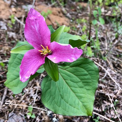
Robinson knows wildflowers and can discuss them for hours with the groups she leads through the area. Talking to a group of about 15 nature lovers on a recent hike through the Catherine Creek area near Lyle, Washington, she hands out a sheet listing over 40 springtime wildflowers that can be seen from the trail. Catherine Creek, she explains, is unique in that the glacial floods left shallow soil. "Catherine Creek is a big area of that special shallow soil habitat where you get a myriad of species of small plants that thrive," she says, explaining that these plants can't compete in deeper soil where tall grasses crowd them out. "In the spring they make a tapestry or carpet of beautifully interwoven color," she says.
Pointing to a carpet of purple-colored Camas that paints a bluff along the trail, Robinson says that the Camas were an important food source for Native Americans. They built pits, lined them with hot rocks, covered them and cooked the root for several days to make them palatable.
Robinson's group, along with the State of Washington and the U.S. Forest Service, also helps manage the nearby Klickitat Trail, which follows the first 31 miles of an old railroad corridor linking the Washington towns of Goldendale and Lyle. It is part of more than 12,000 miles of rail-trails across America that have been created along inactive railroad corridors. The Spokane, Portland, & Seattle Railroad first built the original rail line linking the two towns in 1903. Lumber was king, and the railroad was an important transportation route for the industry until the 1980s. The right-of-way was eventually purchased and transferred to the State in 1994, and the Klickitat Trail Conservancy was formed in 2003. The trail offers year-round recreational opportunities including hiking, mountain biking, cross-country skiing, birding and fishing.
Talk of conservation of the Columbia Gorge took root when the Columbia Gorge Highway was completed 100 years ago. A like-minded group of conservationists led by John Yeon, son of the highway builder, helped form the Friends of the Columbia Gorge while at a picnic across from Multnomah Falls in July 1980. By 1986, the group, led by Nancy Russell, helped secure permanent federal protection of an area of the gorge spanning two states and six counties. The Catherine Creek and Klickitat Trails are part of the overall Columbia River Gorge National Scenic Area.
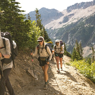
Today, the Friends of the Columbia Gorge continues its work in helping shape land use decisions in the area. As part of its outreach effort, the group offers more than 100 organized hikes, outings, and events in the region from spring through fall in partnership with groups such as the Klickitat Trail Conservancy. Robinson sums up her special fondness for the area. "It has been the joy of my life to see some of this beautiful special habitat preserved so everyone can enjoy it."
Friends of the Columbia Gorge states its position on the Nestlé water rights transfer in the Columbia River Gorge National Scenic Area:
> Creek Water Withdrawal: Oregon
Department of Fish and Wildlife (ODFW) has applied to transfer a public water right to the City of Cascade Locks solely to benefit Nestlé's goal of taking water from Herman Creek for a new bottling plant in Cascade Locks. Friends opposes the transfer and does not support the project.
> Not in Public Interest: This transfer is inconsistent with ODFW's mission. The ODFW is deliberately ignoring the public's interest by applying for a transfer of water right, instead of a change-in-use of a water right. Transfers do not require a public interest test while change-in-use applications do.